Coordinates#
This section of the guide introduces how coordinates are represented in sunpy.
sunpy makes use of the astropy.coordinates module for this task.
In much the same way as units are used for representing physical quantities, sunpy uses astropy.coordinates to represent points in physical space.
This applies to both points in 3D space and projected coordinates in images.
The astropy coordinates module is primarily used through the SkyCoord class, which also makes use of the astropy units system:
>>> from astropy.coordinates import SkyCoord
>>> import astropy.units as u
To enable the use of the solar physics specific frames defined in sunpy we also need to import them:
>>> from sunpy.coordinates import frames
A SkyCoord object to represent a point on the Sun can then be created:
>>> coord = SkyCoord(70*u.deg, -30*u.deg, obstime="2017-08-01",
...                  frame=frames.HeliographicStonyhurst)
>>> coord
<SkyCoord (HeliographicStonyhurst: obstime=2017-08-01T00:00:00.000, rsun=695700.0 km): (lon, lat) in deg
    (70., -30.)>
This SkyCoord object can then be transformed to any other coordinate frame defined either in Astropy or sunpy (see Supported Coordinate Systems for a list of sunpy frames), for example to transform from the original Stonyhurst frame to a Helioprojective frame:
>>> coord.transform_to(frames.Helioprojective(observer="earth"))
<SkyCoord (Helioprojective: obstime=2017-08-01T00:00:00.000, rsun=695700.0 km, observer=<HeliographicStonyhurst Coordinate for 'earth'>): (Tx, Ty, distance) in (arcsec, arcsec, km)
    (769.96270814, -498.89715922, 1.51668773e+08)>
It is also possible to convert three dimensional positions to astrophysical frames defined in Astropy, for example ICRS.
>>> coord.transform_to('icrs')
<SkyCoord (ICRS): (ra, dec, distance) in (deg, deg, km)
  (49.84856512, 0.05394699, 1417743.94689472)>
SkyCoord and all coordinate frames support array coordinates.
These work the same as single-value coordinates, but they store multiple coordinates in a single object.
When you’re going to apply the same operation to many different coordinates, this is a better choice than a list of SkyCoord objects, because it will be much faster than applying the operation to each SkyCoord in a for loop:
>>> coord = SkyCoord([-500, 400]*u.arcsec, [100, 200]*u.arcsec, frame=frames.Helioprojective)
>>> coord
<SkyCoord (Helioprojective: obstime=None, rsun=695700.0 km, observer=None): (Tx, Ty) in arcsec
    [(-500.,  100.), ( 400.,  200.)]>
>>> coord[0]
<SkyCoord (Helioprojective: obstime=None, rsun=695700.0 km, observer=None): (Tx, Ty) in arcsec
    (-500.,  100.)>
Observer Location#
Both Helioprojective and Heliocentric frames are defined based on the position of the observer.
Therefore to transform either of these frames to a different frame the location of the observer must be known.
The observer can be specified for a coordinate object using the observer argument to SkyCoord.
For sunpy to calculate the location of Earth or another solar-system body, it must know the time associated with the coordinate; this is specified with the obstime argument.
Using the observer location it is possible to convert a coordinate as seen by one observer to a coordinate seen by another:
>>> hpc = SkyCoord(0*u.arcsec, 0*u.arcsec, observer="earth",
...                 obstime="2017-07-26",
...                 frame=frames.Helioprojective)

>>> hpc.transform_to(frames.Helioprojective(observer="venus",
...                                          obstime="2017-07-26"))
<SkyCoord (Helioprojective: obstime=2017-07-26T00:00:00.000, rsun=695700.0 km, observer=<HeliographicStonyhurst Coordinate for 'venus'>): (Tx, Ty, distance) in (arcsec, arcsec, AU)
    (-1285.47497992, 106.20918654, 0.72405937)>
Using Coordinates with Maps#
sunpy Map uses coordinates to specify locations on the image, and to plot overlays on plots of maps.
When a Map is created, a coordinate frame is constructed from the header information.
This can be accessed using .coordinate_frame:
>>> import warnings
>>> from astropy.coordinates import SkyCoord
>>> import astropy.units as u
>>> from astropy.io.fits.verify import VerifyWarning
>>> import sunpy.map
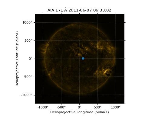
>>> from sunpy.data.sample import AIA_171_IMAGE
>>> with warnings.catch_warnings():
... warnings.simplefilter("ignore", category=VerifyWarning)
... amap = sunpy.map.Map(AIA_171_IMAGE)
>>> amap.coordinate_frame
<Helioprojective Frame (obstime=2011-06-07T06:33:02.880, rsun=696000.0 km, observer=<HeliographicStonyhurst Coordinate (obstime=2011-06-07T06:33:02.880, rsun=696000.0 km): (lon, lat, radius) in (deg, deg, m)
(-0.00406429, 0.04787238, 1.51846026e+11)>)>
This can be used when creating a `~astropy.coordinates.SkyCoord` object to set the coordinate system to that image:
>>> coord = SkyCoord(100 * u.arcsec, 10*u.arcsec, frame=amap.coordinate_frame)
>>> coord
<SkyCoord (Helioprojective: obstime=2011-06-07T06:33:02.880, rsun=696000.0 km, observer=<HeliographicStonyhurst Coordinate (obstime=2011-06-07T06:33:02.880, rsun=696000.0 km): (lon, lat, radius) in (deg, deg, m)
    (-0.00406429, 0.04787238, 1.51846026e+11)>): (Tx, Ty) in arcsec
    (100., 10.)>
The SkyCoord object can be converted to a pair of pixels using GenericMap.wcs.world_to_pixel:
>>> pixels = amap.wcs.world_to_pixel(coord)
>>> pixels
(array(551.7680511), array(515.18266871))
This SkyCoord object could also be used to plot a point on top of the map:
>>> import matplotlib.pyplot as plt

>>> fig = plt.figure()
>>> ax = plt.subplot(projection=amap)
>>> amap.plot()
<matplotlib.image.AxesImage object at ...>
>>> ax.plot_coord(coord, 'o')
[<matplotlib.lines.Line2D object at ...]
(Source code, png, hires.png, pdf)
For more information on coordinates see Coordinates.