What’s New in SunPy 2.0?#
Overview#
The SunPy project is pleased to announce the 2.0 release of the sunpy package. On this page, you can read about some of the big changes in this release:
SunPy 2.0 also includes a large number of smaller improvements and bug fixes, which are described in the Full Changelog.
By the numbers:
1044 commits have been added since 1.1
144 issues have been closed since 1.1
290 pull requests have been merged since 1.1
33 people have contributed since 1.1
16 new contributors
Increase in required package versions#
We have bumped the minimum version of several packages we depend on:
numpy>=1.15.0
scipy>=1.0.0
matplotlib>=2.2.2
astropy>=3.2
parfive>=1.1.0
Search Attributes#
To search with Fido, you need to specify attributes to search against.
Before sunpy 2.0, you had to supply values, as the following example demonstrates:
>>> from sunpy.net import Fido, attrs as a
>>> Fido.search(a.Time('2012/3/4', '2012/3/6'), a.Instrument("norh"),
...             a.Wavelength(17*u.GHz))
There was no way to know if the value was correct, but now we have a extenstive list of supported values from the clients and servers we can request data from.
Using Instrument as an example, if you print the object:
>>> print(a.Instrument)
sunpy.net.attrs.Instrument

Specifies the Instrument name for the search.

       Attribute Name          Client          Full Name                                           Description
--------------------------- ----------- ------------------------ --------------------------------------------------------------------------------
aia                         VSO         AIA                      Atmospheric Imaging Assembly
bbi                         VSO         BBI                      None
bcs                         VSO         BCS                      Bragg Crystal Spectrometer
bic_hifi                    VSO         BIC-HIFI                 None
bigbear                     VSO         Big Bear                 Big Bear Solar Observatory, California TON and GONG+ sites
...
This will list the name of value you should use, what data source will supply that data and a description.
Furthermore, you can use tab completion to auto-fill the attribute name, for example by typing a.Instrument.<TAB>.
So now you can do the following instead:
Fido.search(a.Time('2012/3/4', '2012/3/6'), a.Instrument.norh, a.Wavelength(17*u.GHz))
aiaprep is now deprecated#
With the release of the new aiapy package, sunpy.instr.aia.aiaprep will be removed in version 2.1.
Equivalent functionality is provided by the register() function in aiapy. For more
details, see the example on registering and aligning level 1 AIA images
in the aiapy documentation.
Fixes and clarification to pixel indexing#
sunpy uses zero-based indexing when referring to pixels, where the center of the bottom left pixel of a map is at [0, 0] * u.pix.
Several parts of the API have been updated to make sure this is consistently the case across the package.
In particular:
sunpy.map.GenericMap.top_right_coordpreviously had an off-by-one error in the calculation of the top right coordinate. This has been fixed.sunpy.map.GenericMap.centerpreviously had an off-by-one error in the calculation of the coordinate of the center of a map. This has been fixed.sunpy.map.GenericMap.reference_pixelnow returns a zero-based reference pixel. This is one pixel less than the previously returned value. Note that this means thereference_pixelnow does not have the same value as the FITSCRPIXvalues, which are one-based indices.sunpy.map.header_helper.make_fitswcs_header()now correctly interprets thereference_pixelargument as being zero-based, in previous releases it incorrectly interpreted thereference_pixelas one-based.
Standardization of submap and sunpy.map.GenericMap.draw_rectangle#
Both submap and sunpy.map.GenericMap.draw_rectangle allow specification of “rectangles” in world (spherical) coordinates.
In versions prior to 2.0 you passed the coordinates of the rectangle to draw_rectangle as a bottom left coordinate, and a height and width, but for submap you passed it as a bottom left and a top right.
In 2.0 the way you call both methods has changed, to accept a bottom left and then either width and height or a top right coordinate.
As part of this change, the top_right, width, and height arguments must always be keyword arguments, i.e. width=10*u.arcsec
This change allows you to give the same rectangle specification to submap as to sunpy.map.GenericMap.draw_rectangle.
Which is especially useful when you wish to plot a cropped area of a map, along with it’s context in the parent map:
>>> import astropy.units as u
>>> from astropy.coordinates import SkyCoord
>>> import matplotlib.pyplot as plt

>>> import sunpy.map
>>> from sunpy.data.sample import AIA_171_IMAGE

>>> aia = sunpy.map.Map(AIA_171_IMAGE)

>>> bottom_left = SkyCoord(-100 * u.arcsec, -100 * u.arcsec, frame=aia.coordinate_frame)
>>> width = 500 * u.arcsec
>>> height = 300 * u.arcsec

>>> sub_aia = aia.submap(bottom_left, width=width, height=height)

>>> fig = plt.figure()
>>> ax1 = fig.add_subplot(1, 2, 1, projection=aia)
>>> aia.plot(axes=ax1)
>>> aia.draw_rectangle(bottom_left, width=width, height=height)

>>> ax2 = fig.add_subplot(1, 2, 2, projection=sub_aia)
>>> sub_aia.plot(axes=ax2)
Both these methods delegate the input parsing to a new utility function sunpy.coordinates.utils.get_rectangle_coordinates.
Graphical overview for Map and MapSequence#
There are new methods to produce graphical overviews for Map and MapSequence instances: quicklook() and quicklook(), respectively.
This graphical overview opens the default web browser and uses HTML to show a table of metadata, a histogram of the pixel values in the data, and a histogram-equalized image of the data.
Here’s an example of the output for a MapSequence instance:
<sunpy.map.mapsequence.MapSequence object at 0x744f5c19eb60>
MapSequence of 3 elements, with maps from HMIMap, EITMap, AIAMap
If you are using Jupyter Notebook, there is no need to call these methods explicitly to see this graphical overview. If you type just the name of the instance, the graphical overview is shown within the notebook itself as a rich representation of the instance, instead of the typical text representation.
Differential rotation in the coordinate framework#
The rotation rate of solar features varies with heliographic latitude, this rotation is called “differential rotation”.
SunPy has already included functionality in the sunpy.physics.differential_rotation module to transform coordinates and Maps to account for the rotation of the Sun.
SunPy now provides differential-rotation functionality integrated directly into the coordinate framework using the RotatedSunFrame class.
Here are examples of using this class:
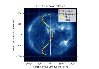
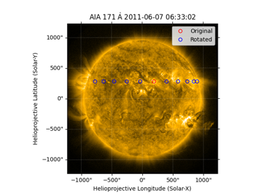
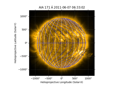
A detailed write-up of how to use RotatedSunFrame can be found at the RotatedSunFrame documentation.
Changes to Carrington coordinates#
We have refined our approach for heliographic Carrington coordinates to best support high-resolution imagery of the Sun, including from observatories that are at distances from the Sun that is significantly different from 1 AU (e.g., Solar Orbiter).
Our HeliographicCarrington coordinate frame is now expressly intended for the co-alignment of images of the Sun’s surface from different observatories.
HeliographicCarrington now requires the specification of the observer location (Earth or otherwise) because the light travel time between the Sun and the observer is accounted for.
SunPy output now matches the calculations by JPL Horizons and SPICE.
There may be small differences compared to Carrington coordinates computed by groups that do not use modern parameter values or the same assumptions for the methodology.
Importantly, the Carrington longitude that is now calculated (including using sunpy.coordinates.sun.L0()) will not match earlier versions of SunPy.
A detailed write-up of the calculation approach and comparisons to other resources can be found at carrington’s functionality documentation.
Download behind proxies#
With the release of parfive 1.1, sunpy has been patched to be able to utilize proxy servers when downloading files.
Proxy URL is read from the environment variables
HTTP_PROXYorHTTPS_PROXY.Proxy Authentication
proxy_authshould be passed as aaiohttp.BasicAuthobject, explicitly by the user.Proxy Headers
proxy_headersshould be passed asdictobject, explicitly by the user.
For example if you use a bash terminal:
$ HTTP_PROXY=http://user:password@proxyserver.com:3128
$ HTTPS_PROXY=https://user:password@proxyserver.com:3128
$ export HTTP_PROXY
$ export HTTPS_PROXY
these will be used to enable downloads through a proxy.
Citation update#
A paper discussing sunpy 1.0 was accepted in The Astrophysical Journal and you can find the bibtex for it by running:
>>> import sunpy
>>> sunpy.__citation__
Previous update: sunpy 1.1#
In case you never updated to the intermediate release (sunpy 1.1) the whatsnew contains the major changes from that release: What’s New in SunPy 1.1?